水上物流产品分类
-
豪华私人船,多设施,旅行探险
-
快速水上运动艇,多用途
-
利用风力的船,多种用途
-
设备多样,功能全面
-
多样刺激,乐趣无限
-
船只停靠的场所,设施齐备


散货运输船导航软件(专业用途船报警系统)
产品图片

 |
 |
重要参数
| 类型 | 导航, 分析, 记录, AIS, 领航员航海水平测试 |
| 应用领域 | 散货运输船, 专业用途船, 用于港口, 近海平台 |
| 其他特性 | 用于平板电脑, 用于报警系统 |
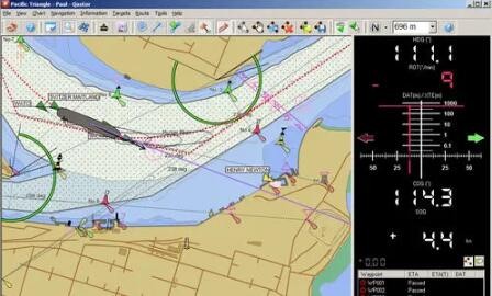
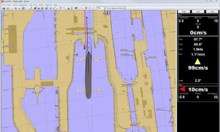
产品简介QPS(Quality Positioning Services BV)的Qastor是一款功能强大的电子海图系统,为飞行员提供易于使用和易于理解的信息。 自2000年以来,QPS一直在为航海飞行员开发便携式电子海图和导航系统。Qastor 是作为标准软件许可证提供的,并有多个附加模块,以满足端口和飞行员的个性化需求。目前,该软件被授权给一个物理加密狗 - 可用的选项是USB或Express Card/34。 Qastor(2.50版本)提供了综合语音记录功能。这对于分析航行或培训是非常实用的。对于松下CF-19的用户,或者其他没有集成麦克风的机器,需要插入麦克风或者使用蓝牙麦克风。 标准的Qastor许可证是用于导航模式的,其中包含以下功能: 探测和避免危险 加强路线规划和核查 动态龙骨下间隙 在狭窄水域精确航行 实时降潮 扫荡路径船只预测 AIS集成和目标查看器,具有高级CPA功能。 录制和重播 DXF覆盖 S-57 ENCs、ARCS或 "C-Map Professional "海图 互动式潮汐高度 创建路线 监测转弯的曲线路径预测 手动关闭距离 全面显示所有的AIS数据,可以是综合AIS数据,也可以是Pilot Plug数据。 用于快速识别船舶数据的AIS数据库。 预测CPA并计算AIS目标的会合点,包括视线或沿线。 全程录音和重播 英文介绍Qastor, by QPS (Quality Positioning Services BV), is a powerful electronic charting system that gives pilots easy-to-use and easy-to-understand information. QPS has been developing portable electronic charting and navigation systems for the marine pilot since 2000.Qastor is offered as a standard software licence with several add-on modules to suit the individual needs of ports and pilots. Currently the software is licensed to a physical dongle - available options are USB or Express Card/34. Integrated voice recording is available in Qastor (2.50 version). This can be very practical for analysis of the voyage or training. For users of Panasonic CF-19s, or other machines that do not have an integrated microphone, it is necessary to either plug in a microphone or to use a Bluetooth microphone. The standard Qastor licence is for Navigation Mode, which contains features such as: Danger detection and avoidance Enhanced route planning and verification Dynamic under keel clearance Accurate navigation in confined waters Real-time tide reduction Swept path vessel prediction AIS integration and target viewer with advanced CPA functions Recording and replay DXF overlay S-57 ENCs, ARCS or 'C-Map Professional' charts Interactive Height of Tide Route creation Curved path prediction for monitoring turns Manual distance-off Full display of all AIS data, either from integrated AIS or from Pilot Plug AIS Database for speedy recognition of vessel data Predict CPAs and calculate meeting points of AIS target, both Line-Of-Sight or Along Route Full recording and replay |
| 上一篇:航海管理软件(港口监控软件) | 下一篇:海港用船队管理软件 |
推荐信息
| 高质量重型侧卸车(侧移式升降机) |
2023-10-17
|
查看详情 >> |
| 船用搬运千斤顶(微型电动履带运输车) |
2023-11-25
|
查看详情 >> |
| 水产养殖下锚 |
2023-12-12
|
查看详情 >> |
| 高密度的漂浮式模块 |
2024-01-23
|
查看详情 >> |
| 电动船坞牵引拖车 |
2023-11-02
|
查看详情 >> |